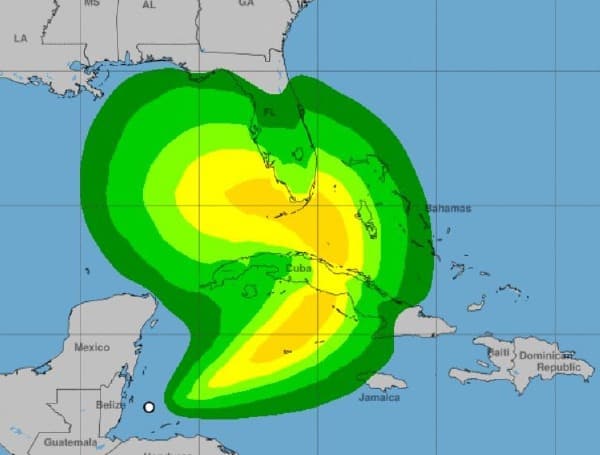
Eta has intensified into a tropical storm with 50 mph winds. The center of Tropical Storm Eta is located about 500 miles south of Fort Myers and is moving northeast at 17 mph. Tropical storm watches and warnings have been issued for southwest and southeast Florida.
There is higher than normal uncertainty on when Eta is forecast to turn back to the west on Monday. A later turn to the west would bring the track of Eta closer to the right side of the forecast cone with a larger area of tropical storm impacts in Southwest and West Central Florida. A track favoring the left side of the forecast cone would lessen the impacts in Southwest Florida and West Central Florida. Strong winds, heavy rainfall, and dangerous marine conditions are possible for our area.
Wind: As of the current forecast, Hernando County has a 10 to 20% chance of receiving tropical-storm-force winds (sustained winds greater than 39 mph). The forecasted time of arrival is 4:00 a.m. to 8:00 p.m. on Monday.
Surge: Monday night tides are forecasted to be 1 to 2 feet below normal due to offshore wind flow. Tuesday and Wednesday, if Eta tracks closer to the coast, we could see 3 to 5 feet above ground level (mean high high water). If it tracks further from the coast, expect 2 to 3 feet above normal tides (mean high high water).
Rain: Just over an inch of rain is forecast for our area through Wednesday.
However, any changes in the forecast track is likely to also change the rainfall forecast.
There remains a high degree of uncertainty in the track, magnitude, and timing of this system. It is important that residents monitor the progress of this system over the next several days. Residents are also encouraged to refresh their emergency supply kits and ensure that their disaster plan is in place.

