August 26, 2020
By: Staff Report
Intracoastal City, LA.- Unsurvivable storm surge with large and destructive waves will cause catastrophic damage from Sea Rim State Park, Texas, to Intracoastal City, Louisiana, including Calcasieu and Sabine Lakes. This surge could penetrate up to 30 miles inland from the immediate coastline. Only a few hours remain to protect life and property and all actions should be rushed to completion.
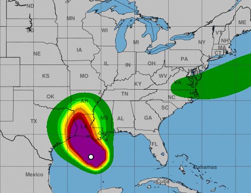
Hurricane-force winds are expected tonight in portions of the hurricane warning area from San Luis Pass, Texas, to west of Morgan City, Louisiana, with catastrophic wind damage expected where Laura’s eyewall makes landfall. Hurricane-force winds and widespread damaging wind gusts will spread well inland across portions of eastern Texas and western Louisiana early Thursday.

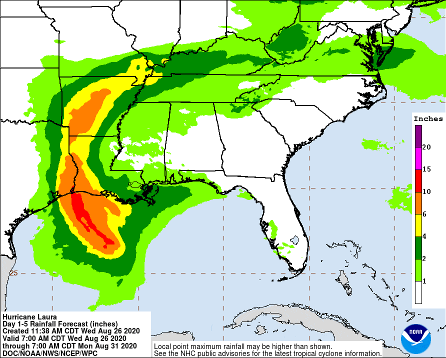
Widespread flash flooding along small streams, urban areas, and roadways is expected to begin this afternoon into Thursday from far eastern Texas, across Louisiana and Arkansas. This will also lead to minor to isolated moderate freshwater river flooding. The heavy rainfall threat and localized flash and urban flooding potential will spread northeastward into the middle-Mississippi, lower Ohio and Tennessee Valleys Friday night and Saturday.
Watch LIVE as Hurricane Laura Approaches Lake Charles Louisiana
SUMMARY OF WATCHES AND WARNINGS IN EFFECT:
A Storm Surge Warning is in effect for…
- Freeport Texas to the Mouth of the Mississippi River
A Hurricane Warning is in effect for…
- San Luis Pass Texas to Intracoastal City Louisiana
A Tropical Storm Warning is in effect for…
- Sargent Texas to San Luis Pass
- East of Intracoastal City Louisiana to the Mouth of the
Mississippi River
A Storm Surge Watch is in effect for…
- Mouth of the Mississippi River to Ocean Springs Mississippi
- Lake Pontchartrain, Lake Maurepas, and Lake Borgne
A Hurricane Watch is in effect for…
- East of Intracoastal City to west of Morgan City Louisiana
The combination of a dangerous storm surge and the
tide will cause normally dry areas near the coast to be flooded by
rising waters moving inland from the shoreline. The water could
reach the following heights above ground somewhere in the indicated
areas if the peak surge occurs at the time of high tide…
- Johnson Bayou LA to Rockefeller Wildlife Refuge including Calcasieu
Lake…15-20 ft - Sea Rim State Park TX to Johnson Bayou LA including Sabine
Lake…10-15 ft - Rockefeller Wildlife Refuge to Intracoastal City LA…10-15 ft
Intracoastal City LA to Morgan City including Vermilion Bay…8-12
ft - Port Bolivar TX to Sea Rim State Park…6-9 ft
- Morgan City LA to Mouth of the Mississippi River…4-7 ft
- Freeport TX to Port Bolivar including Galveston Bay…2-4 ft
- Mouth of the Mississippi River to Ocean Springs MS including Lake
Borgne…2-4 ft - Lake Pontchartrain and Lake Maurepas…2-4 ft
The deepest water will occur along the immediate coast near and to
the right of the landfall location, where the surge will be
accompanied by large and destructive waves.
Unsurvivable storm surge with large and destructive waves will cause catastrophic damage from Sea Rim State Park, Texas, to Intracoastal City, Louisiana, including Calcasieu and Sabine Lakes. This storm surge could penetrate up to 30 miles inland from the immediate coastline in southwestern Louisiana and far southeastern Texas.
Surge-related flooding depends on the relative timing of the surge and the tidal cycle, and can vary greatly over short distances. For information specific to your area, please see products issued by your local National Weather Service forecast office.

