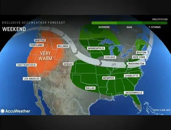
A persistent pattern of dangerous thunderstorms is set to impact over 100 million people across dozens of states east of the Rockies, particularly throughout the southern U.S., with a daily barrage of severe storms and drenching rain expected through the first full weekend of June and into next week. AccuWeather meteorologists are urging vigilance as the hot, humid summer air continues to fuel this prolonged period of hazardous weather.
Since the beginning of June, the region has already experienced hundreds of reports of wind damage, large hail, and even a few tornadoes. Many of the same areas that have recently been hit will need to remain alert for ongoing storminess, potentially lasting until at least Monday.
READ: Florida Beaches Breathe Easy: No Red Tide Detected Statewide For The Past Week
“A series of low pressure areas moving into and then out of the Midwest through early next week will be the impetus for the successive severe weather risks from the Plains to the Southeast,” stated AccuWeather Senior Meteorologist Chad Merrill.
The latest round of storms has already brought giant hail, hurricane-force winds, and several tornadoes across the southern Plains through Friday morning. This dangerous weather is expected to advance eastward across the Mississippi and Tennessee River valleys by the end of the week, with strong, drenching storms even anticipated in parts of the Northeast.
Weekend plans for Saturday could be significantly disrupted across a vast expanse from the U.S.-Mexico border to the mid-Atlantic coast. Beyond the threat of hail, destructive winds, and lightning, heavy rainfall is a major concern, as storms are likely to repeatedly track over the same areas.
READ: Clearwater Gears Up For Hurricane Season With June 21 Expo At Coachman Park
“Besides the severe weather threat, repeated downpours will move over already-saturated soil,” Merrill added. “Motorists will have to watch out for ponding of water on roads, and smaller creeks and streams will be susceptible to overflowing their banks.”
Of particular concern for potential flooding is eastern Oklahoma into southern Kansas, including Wichita, an area that has already accumulated a surplus of 2 to 5 inches of rain in early June.
Looking ahead to Sunday, at least two distinct areas of severe weather are forecast to develop across the Midwest, southern Plains, and Southeast. Major metropolitan areas such as Atlanta, Chicago, Dallas, and St. Louis are directly in the path of these violent storms, which are also expected to cause widespread air travel disruptions due to their impact on numerous busy airport hubs.
The Red River Valley of Texas and Oklahoma faces an elevated risk of dangerous storms as the weekend concludes, with AccuWeather meteorologists considering the rare possibility of issuing a “high risk” for severe storms in this area. The severe threat will not dissipate with the weekend, as the southern Plains and South are at “some risk” for gusty storms on Monday, marking what could be the fourth consecutive day of severe weather for some locales.
READ: From Rays To Twins: Rocco Baldelli’s Enduring Love For Tampa Bay On ‘The Rock Stops Here’
While damaging winds, large hail, and torrential rain remain the primary threats, a few tornado touchdowns have occurred in recent days, and AccuWeather meteorologists are concerned for additional tornado activity during this prolonged event. Merrill warned, “A couple of tornadoes can occur in the High Plains into Friday evening. On Saturday, the threat for tornadoes will shift south and east into the moderate risk area in the mid-South, between Interstates 20 and 40.”
Due to the substantial moisture in the atmosphere, any tornadoes that form could be “rain-wrapped,” making them extremely difficult to see and particularly dangerous, especially after dark.
As outdoor graduations and summer vacation plans begin, AccuWeather emphasizes the critical importance of having a reliable method to receive severe weather warnings, both at home and while traveling, to ensure timely protective action.
Please make a small donation to the Tampa Free Press to help sustain independent journalism. Your contribution enables us to continue delivering high-quality, local, and national news coverage.
Connect with us: Follow the Tampa Free Press on Facebook and Twitter for breaking news and updates.
Sign up: Subscribe to our free newsletter for a curated selection of top stories delivered straight to your inbox.

