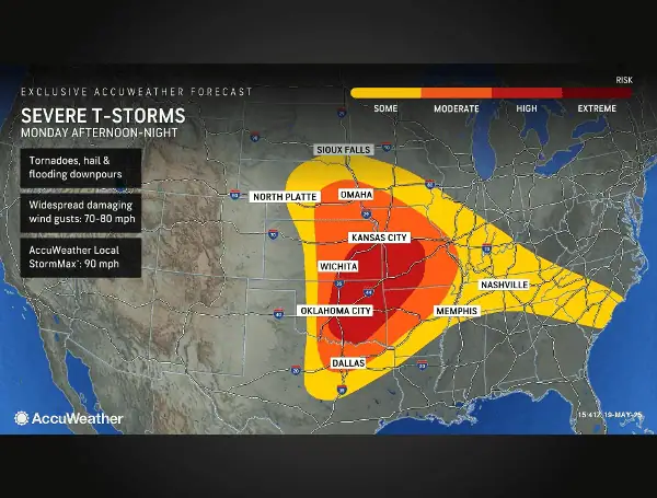
Just days after a devastating severe weather outbreak claimed at least 28 lives across Missouri, Kentucky, Illinois, and Indiana, AccuWeather expert meteorologists are warning of another significant threat looming over the central United States.
A new volatile stretch of severe weather is forecast to impact the region through the middle of the week, including communities still grappling with the aftermath of recent tornadoes.
A “high” risk of severe thunderstorms has been issued for parts of southeastern Kansas, eastern Oklahoma, southwestern Missouri, and northwestern Arkansas through late Monday night.
This zone, which includes portions of the Ozark Mountains, could see storms capable of producing tornadoes, hail, flooding downpours, and widespread damaging wind gusts reaching 70-80 mph, with localized gusts potentially hitting an AccuWeather Local StormMax of 90 mph. The overall area at risk for some thunderstorm activity on Monday stretches from South Dakota down to central Texas.
READ :Florida Gas Prices Dip Ahead Of Record-Breaking Memorial Day Travel
“This has been an extremely stormy and dangerous stretch of weather for the central United States, and the danger isn’t over yet,” warned AccuWeather Chief Meteorologist Jonathan Porter. “Families, businesses, and communities trying to recover from devastating tornadoes could be hit by more severe weather over the next 48 hours. Buildings that were damaged and left compromised by recent tornadoes and severe wind gusts could be damaged yet again as this next round of storms moves through the region.”
The current threat follows a brutal few days that saw dozens of tornadoes touch down across the central and eastern US on May 15th, 16th, and 17th. Adding to the recent onslaught, AccuWeather™ meteorologists reported over 30 additional tornado reports on Sunday, stretching from northeastern Colorado through northwestern Oklahoma. More than 150 hail reports were also filed on Sunday, including a massive 4.5-inch hailstone near Arnett, Oklahoma.
The danger is expected to continue into the late-night hours, a particularly concerning factor as nocturnal tornadoes are statistically 2.5 times deadlier than daytime tornadoes. “We expect severe thunderstorms to spin up roughly two dozen tornadoes today in the middle of the country. Some of these storms and tornadoes could impact towns hit hard by the severe weather outbreak just a few days ago,” said AccuWeather Chief On-Air Meteorologist Bernie Rayno.
READ: Jacksonville Woman Claims Massive $16 Million Florida Lottery Scratch-Off Prize
“There is the potential for multiple tornadoes ongoing at the same time Monday afternoon and evening across the central Plains. The atmosphere is primed for another dangerous day,” said Sr. Director of Forecasting Operations Dan DePodwin. “In addition to tornadoes, there can be swaths of destructive winds from thunderstorms perhaps between 75 and 85 mph in some spots from Oklahoma to Missouri.”
Residents across the affected region are strongly urged to restock emergency supplies and ensure their storm shelters and safe rooms are ready. With the persistent threat extending into the overnight hours, having multiple ways to receive severe weather warnings that can rouse them from sleep is crucial. AccuWeather™ highlights that their app is proven to deliver life-saving warnings faster than other sources.
On Tuesday, the severe weather threat will shift eastward, targeting the Missouri, Tennessee, and Ohio valleys. AccuWeather has issued a moderate risk for parts of Louisiana, Mississippi, Alabama, Georgia, Arkansas, Tennessee, Missouri, Illinois, Indiana, Kentucky, and Ohio.
These areas could see tornadoes, large hail, flooding downpours, and damaging wind gusts of 70-80 mph, with an AccuWeather Local StormMax of 90 mph possible through Tuesday night. The continued rounds of thunderstorms and heavy rainfall, fueled by Gulf moisture, will also elevate the risk of flash flooding and flooded farm fields.
READ :“Very Well”: Trump Claims Putin Ready For Immediate Ukraine Peace Talks
The impending severe weather poses a significant challenge to ongoing cleanup and recovery efforts in areas recently devastated by tornadoes. Strong winds, hail, and flooding rain could damage temporary repairs like tarps on roofs and turn unsecured construction equipment into dangerous debris.
By Wednesday, the severe thunderstorm threat will advance to the Southeast coast, potentially impacting areas from New Orleans to northern Florida, and along the East Coast through the Carolinas to Washington, D.C., with the risk of isolated tornadoes, hail, flooding downpours, and localized damaging winds.
This prolonged period of severe weather is expected to cause disruptions to travel, business operations, and supply chain logistics across the central and eastern US through Wednesday night. Agricultural operations may also face challenges due to flooded and muddy fields.
AccuWeather meteorologists urge residents in the affected areas to stay informed, monitor weather alerts closely, and take necessary precautions to ensure their safety.
Please make a small donation to the Tampa Free Press to help sustain independent journalism. Your contribution enables us to continue delivering high-quality, local, and national news coverage.
Connect with us: Follow the Tampa Free Press on Facebook and Twitter for breaking news and updates.
Sign up: Subscribe to our free newsletter for a curated selection of top stories delivered straight to your inbox.

