AccuWeather expert meteorologists are closely monitoring a dual threat to the United States this week: a renewed risk of severe thunderstorms across the central U.S., impacting communities still recovering from last month’s devastating outbreaks, and the potential for early-season tropical development in the Atlantic basin.
Communities in the central United States, particularly those hit by tornadoes, hail, and damaging wind gusts in May, are bracing for another round of severe weather. AccuWeather meteorologists report that two dynamic storm systems are poised to sweep across the region through midweek.
“A pair of storms is expected to work in tandem to prompt a risk of severe weather across the center of the nation on Monday, with hail, damaging winds and the potential for a few tornadoes,” explained AccuWeather Meteorologist Brandon Buckingham.
READ: Central US Braces For Multi-Day Severe Weather Onslaught Expected Through Midweek
A strengthening jet stream, combined with warm, humid air from the Gulf of Mexico, will fuel these storms. A colliding cold front is expected to further intensify thunderstorm activity across the central and eastern U.S. Severe thunderstorms are likely from western Texas and eastern New Mexico to parts of Minnesota and the Dakotas on Monday afternoon through late Monday night.
AccuWeather forecasts a moderate risk for parts of Texas, Oklahoma, Colorado, Kansas, Nebraska, and South Dakota, with potential for large hail, flooding downpours, and localized damaging wind gusts of 60-70 mph, with an AccuWeather Local StormMax of 80 mph.
The threat shifts eastward on Tuesday, with a moderate risk of severe thunderstorms across parts of Missouri, Iowa, Wisconsin, and Illinois through late Tuesday night.
A few tornadoes, large hail, flooding, and localized damaging wind gusts of 65-75 mph are possible, with an AccuWeather Local StormMax of 85 mph. The severe weather risk continues eastward into Wednesday, stretching from central Texas to the Great Lakes region, bringing potential for hail, flash flooding, and localized damaging wind gusts of 60-70 mph, with an AccuWeather Local StormMax of 80 mph.
READ: Powering Through Peril In Florida: Essential Generator Safety As Hurricane Season Looms
Forecasters note that rainfall totals for May were significantly above average in parts of central and southern Missouri, southeastern Kansas, and Oklahoma, increasing the risk of flooding in already saturated areas.
The severe weather threat will then advance into the Northeast on Thursday, with severe thunderstorms possible across parts of Pennsylvania, New York, New Jersey, Connecticut, Rhode Island, Vermont, New Hampshire, and Maine. This week’s risk of isolated tornadoes, hail, lightning, and flooding downpours could hinder ongoing recovery efforts in areas severely impacted by last month’s multi-day severe weather outbreak, which caused an estimated $9 billion to $11 billion in total damage and economic loss.
Atlantic Eyeing Tropical Development
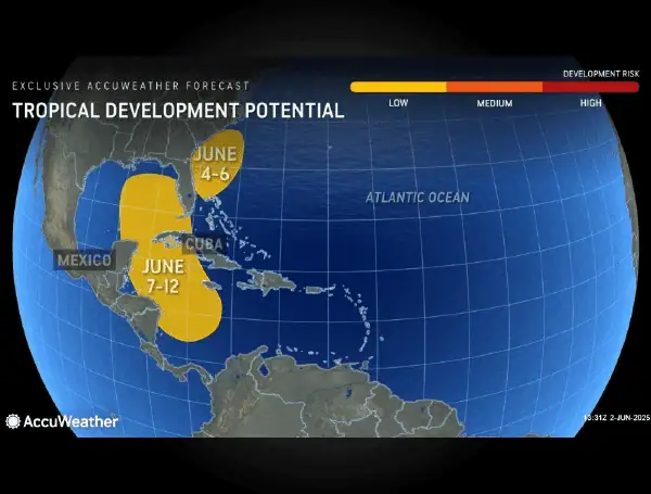
In addition to the severe weather inland, AccuWeather hurricane experts are closely monitoring two zones with a low risk of tropical development potential in the Atlantic basin, starting Wednesday.
“We cannot rule out an area of low-pressure developing off the Carolina coast between Wednesday and Friday this week. Right now, we forecast roughly a 10 percent chance for this to develop,” said AccuWeather® Lead Hurricane Expert Alex DaSilva. “Even if this does not develop into a tropical system, we expect downpours across Florida into the Carolinas, especially along the coast. There will also be rip current risks later in the week along those areas from the Carolinas down through parts of central and southern Florida.”
READ: “Super-Charged” Atlantic Hurricane Season Expected
A low-risk zone for tropical development potential has also been identified in the western Caribbean and eastern Gulf from June 7-12.
DaSilva notes that conditions in this area, including warm sea surface temperatures and abundant moisture, are more conducive for development, although wind shear may inhibit its progression.
Regardless of tropical development, heavy rain is anticipated across Florida, parts of the Bahamas, Cuba, and Jamaica in early June, as a front may stall over the region, leading to potential flooding from repeated downpours.
The first round of heavy rain for Florida is expected Tuesday and Wednesday, spreading northeastward into the coastal Carolinas by Thursday. Coastal hazards such as rip currents, coastal flooding, and beach erosion are also expected along the Carolina coasts and the eastern coast of Florida. The first name on the 2025 Atlantic tropical storm and hurricane list is Andrea.
AccuWeather is also tracking a massive plume of Saharan dust moving east, high above the Caribbean. “The Saharan dust plume is roughly 2,000 miles wide from west to east, stretching from Jamaica all the way past Barbados. North to south, it stretches about 750 miles, spanning from Trinidad and Tobago in the south to north of Puerto Rico,” DaSilva said. “It’s not necessarily unusual for this time of year, but it’s definitely large and will be noticeable along the Gulf Coast.”
READ: Don’t Blink: Atlantic Hurricane Season Kicks Off With Early Storm Threat
This Saharan dust is expected to inch closer to the U.S. later this week, potentially bringing hazy skies and more colorful sunsets to Florida as early as Thursday, and spreading to the northern Gulf Coast by Friday into the weekend. While impacts to air quality are expected to be minimal, DaSilva warns that dust caught in raindrops could leave brown residue on cars and other surfaces.
The AccuWeather 2025 Atlantic Hurricane Season Forecast predicts 13 to 18 named storms, including seven to 10 hurricanes and three to five major hurricanes. AccuWeather® is forecasting three to six direct impacts to the U.S. this year, matching the range forecasted for the historic 2024 Atlantic hurricane season.
Please make a small donation to the Tampa Free Press to help sustain independent journalism. Your contribution enables us to continue delivering high-quality, local, and national news coverage.
Connect with us: Follow the Tampa Free Press on Facebook and Twitter for breaking news and updates.
Sign up: Subscribe to our free newsletter for a curated selection of top stories delivered straight to your inbox.

