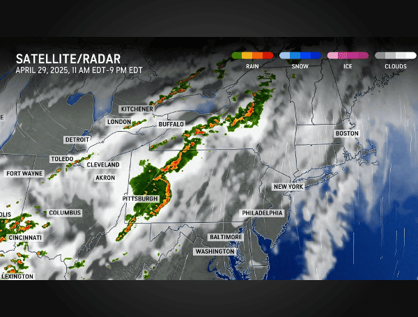
A powerful line of severe thunderstorms intensified into a destructive derecho Tuesday evening, unleashing widespread wind damage across portions of the Ohio Valley and the interior Northeast. AccuWeather meteorologists confirmed the classification of this long-lived storm complex, which has left millions without power and tragically claimed at least one life in Pittsburgh.
“AccuWeather expert meteorologists are classifying this long-lived thunderstorm complex that blasted through Ohio and Pennsylvania as a derecho,” stated Dan DePodwin, AccuWeather Senior Director of Forecasting Operations. “While there have been many days of severe thunderstorms so far this year, this appears to be the first derecho of 2025.”
READ: Gulf Anglers Reminded: Florida Recreational Greater Amberjack Harvest Closed In May
Derechos are characterized by producing straight-line wind damage exceeding 58 mph along a path of at least 400 miles. This particular weather event stretched from near the Ohio-Indiana border, eastward along and north of the Ohio River, and continued through western and central Pennsylvania, surpassing the 400-mile threshold. Significant damage, including downed trees and power lines, has been widely reported, particularly in Pittsburgh.
The ferocious winds, with gusts reaching 60-80 mph, have resulted in widespread power outages. In Pennsylvania alone, more than 550,000 homes and businesses are currently without electricity. Ohio has seen over 80,000 customers lose power, while New York is reporting more than 30,000 outages.
Tragically, authorities in Pittsburgh confirmed one fatality after a man was electrocuted by live power lines that were downed by the storm. Emergency officials are urgently advising residents across Pittsburgh to exercise extreme caution when traveling in the dark due to the numerous hazards posed by fallen trees, live wires, and other storm debris.
READ: ICE, State Police Arrest Illegal Guatemalan After He Strangled A Virginia Woman
In State College, Pennsylvania, multiple drivers found themselves trapped inside their vehicles after live power lines fell onto them, highlighting the dangerous conditions created by the powerful winds.
“The line of storms formed near Indianapolis and continued advancing eastward, bringing widespread tree and power line damage to western and central Pennsylvania,” explained AccuWeather Senior Meteorologist Alan Reppert. “Wind gusts in some areas were nearly 80 mph. For some communities, this derecho could be a once-in-a-10-year or even a once-in-a-20-year event.”
Weather-related power outages were also reported in Missouri and Michigan earlier on Tuesday, indicating the broad reach of the severe weather system.
AccuWeather meteorologists anticipate that the immediate threat from this derecho will subside by midnight as it moves towards the East Coast. However, they caution that additional rounds of severe weather are expected across the eastern half of the country throughout the remainder of the workweek.
READ: Wildfire Underway Near Zephyrhills, No Structures Currently Threatened
Looking ahead, the risk for severe thunderstorms will shift to central Texas and the Dallas-Fort Worth metroplex, extending north into Oklahoma and east into parts of Missouri and Kentucky on Wednesday afternoon and evening. These storms could bring hail, flash flooding, and isolated tornadoes.
By Thursday, the severe weather threat will move eastward again, impacting the Tennessee and Ohio River valleys, including some of the areas already affected by Tuesday’s derecho. Hail, heavy downpours, and isolated tornadoes will be possible.
On Friday, the focus for severe weather will be along parts of the Gulf and East Coast, stretching from Texas to New England, with the potential for hail, heavy rain, and localized damaging winds.
AccuWeather expert meteorologists warn that travel, business operations, and supply chain logistics across the affected regions could face disruptions as the severe weather continues to move through.
Please make a small donation to the Tampa Free Press to help sustain independent journalism. Your contribution enables us to continue delivering high-quality, local, and national news coverage.
Connect with us: Follow the Tampa Free Press on Facebook and Twitter for breaking news and updates.
Sign up: Subscribe to our free newsletter for a curated selection of top stories delivered straight to your inbox.

