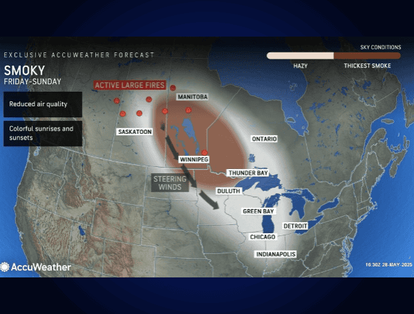
Residents across vast portions of the United States should prepare for diminished air quality and hazy skies from two distinct atmospheric phenomena in the coming days. AccuWeather expert meteorologists are tracking smoke from significant Canadian wildfires expected to drift into the northern U.S. later this week, while simultaneously forecasting the arrival of Saharan dust plumes over the Gulf Coast and Florida starting this weekend.
Steering winds are already beginning to channel smoke southeastward from large blazes across British Columbia, Saskatchewan, and Manitoba. According to AccuWeather, this smoke is anticipated to enter parts of the northern Plains and Midwest late this week and persist through the weekend.
READ: NOAA’s Warning To Florida: Above-Average Hurricane Season Looms For 2025
“Most of the time, the smoke will be high-flying and dim the sun, leading to vivid sunrises and sunsets and causing a hazy appearance to the sky overhead,” explained AccuWeather® Meteorologist Brandon Buckingham. “However, there will be episodes where the smoke can reach the lower levels of the atmosphere and affect visibility and air quality. That could be a safety concern for travel in extreme cases and pose health problems for some individuals with respiratory issues.”
Cities where the smoke is most likely to be noticeably thick include Fargo, North Dakota; Minneapolis and Duluth, Minnesota; Green Bay and Milwaukee, Wisconsin; and Chicago, Illinois. Hazy conditions from high-altitude smoke may also be observed as far south and east as Detroit and Indianapolis. Experts also warn that as heat builds in the western U.S. next week, the combination of hot air and lingering smoke could exacerbate ozone issues across the north-central region.
AccuWeather Senior Meteorologist Adam Douty noted, “Most of these areas in the Midwest will have days where there is little or no rain around and the sun is out over the weekend. So the smoke will be more noticeable.” He added that while the smoke might reach the Northeast, extensive cloud cover and showers in that region could make it less obvious.
READ: Florida Toughens Stance On Animal Cruelty With New Laws Signed By Governor DeSantis
This event draws parallels to the spring and summer of 2023 when Canadian wildfire smoke led to hazardous air quality in major cities like New York. AccuWeather’s long-range experts had previously warned in April that an active late wildfire season in Alberta and British Columbia could lead to smoky skies in the northern Plains and Great Lakes. The AccuWeather® 2025 U.S. Wildfire Forecast predicts that 7 to 9 million acres will burn across America this year, exceeding the historical average.
Saharan Dust to Blanket Southern Skies
Simultaneously, two large Saharan dust clouds are making their way west from Africa. These plumes are expected to bring noticeably hazy skies to parts of Florida and the Gulf Coast.
Satellite imagery on Wednesday morning showed thick dust off the African coast, with a second, lighter swath over the Caribbean. The first, smaller cloud is predicted to create hazy conditions over South Florida by Saturday before dissipating. A larger dust cloud is forecast to move over Florida around June 4, subsequently spreading hazy skies across much of the Gulf Coast late next week.
READ: FBI Offers $20,000 Reward In 1999 California Murder Case, Suspect Believed To Be In Mexico
Fortunately, AccuWeather meteorologists anticipate most of this dust will remain aloft, minimizing direct health concerns at ground level. The primary visible effect will be colorful sunrises and sunsets.
Interestingly, AccuWeather hurricane experts note that significant Saharan dust can inhibit tropical storm formation or intensification due to its drier air (about 50% less moisture than the typical tropical atmosphere) and potential to increase wind shear.
Tropical Development Monitored Despite Dust
Despite the dust’s potential suppressive effects, AccuWeather meteorologists are closely monitoring the Atlantic for tropical storm development as the official start of hurricane season approaches on Sunday, June 1st.
“We will be watching a zone stretching from Florida waters to the Bahamas and Cuba during the first few days of June,” said AccuWeather® Senior Meteorologist Dan Pydynowski. While widespread showers and thunderstorms are expected in this area, potentially easing dry conditions in Florida, tropical development in early June is currently unlikely but remains a possibility. Pydynowski also indicated that a combination of a lingering front, moisture, and a potential tropical wave could stir up tropical trouble in the western and central Caribbean approximately 10 days out, though conditions may not ultimately align for organization.
Please make a small donation to the Tampa Free Press to help sustain independent journalism. Your contribution enables us to continue delivering high-quality, local, and national news coverage.
Connect with us: Follow the Tampa Free Press on Facebook and Twitter for breaking news and updates.
Sign up: Subscribe to our free newsletter for a curated selection of top stories delivered straight to your inbox.

