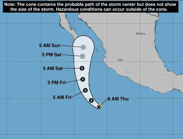
The Eastern Pacific hurricane season has officially kicked off with the formation of Tropical Storm Alvin, the first named storm of 2025. What began as the season’s first tropical depression on Wednesday has now strengthened into a tropical storm, prompting concerns for western Mexico with potential for wind, rain, and pounding surf.
Tropical Storm Alvin is located several hundred nautical miles south of southwestern Mexico. Satellite imagery indicates a significant increase in thunderstorm activity around its center, with a notable improvement in organization.
READ :NOAA’s Warning To Florida: Above-Average Hurricane Season Looms For 2025
While initial estimates remained steady at 35 mph, satellite intensity estimates were higher, ranging from 40 to 52 mph. Based on this consensus, the National Hurricane Center (NHC) has upgraded Alvin’s initial intensity to 40 mph.
Alvin is currently moving northwest at 10 mph. The storm is expected to maintain this general northwestward motion today before gradually turning north-northwest tomorrow as it interacts with a ridge of high pressure over central Mexico. By tomorrow night, a mid-level cut-off low will influence Alvin, directing it northward. The NHC’s track forecast remains consistent with previous advisories.
Forecasters anticipate that Alvin will continue to strengthen today, benefiting from a favorable environment of warm sea surface temperatures and low wind shear for approximately the next 24 hours. The NHC’s peak intensity forecast for Alvin remains at 50 knots (58 mph), which is near the upper end of current model guidance.
READ: Powering Through Peril In Florida: Essential Generator Safety As Hurricane Season Looms
However, a weakening trend is expected to begin tomorrow as Alvin moves into an environment characterized by progressively higher wind shear, drier air, and cooler sea surface temperatures.
There is “high confidence” that the system will weaken to a remnant low before it nears the Baja California Peninsula. While the direct impacts to the Baja California Peninsula are expected to be limited, coastal areas of western Mexico should brace for heightened swells, increased rip currents, and locally heavy rainfall.
Residents and visitors in western Mexico are advised to stay informed about the latest advisories from the National Hurricane Center and local meteorological authorities.
Please make a small donation to the Tampa Free Press to help sustain independent journalism. Your contribution enables us to continue delivering high-quality, local, and national news coverage.
Connect with us: Follow the Tampa Free Press on Facebook and Twitter for breaking news and updates.
Sign up: Subscribe to our free newsletter for a curated selection of top stories delivered straight to your inbox.

