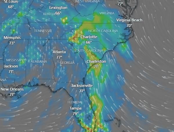
Just eight months after the devastating impact of Hurricane Helene, communities in Western North Carolina are once again facing a serious threat of hazardous rainfall and potential flooding. Forecasters are calling the current situation the region’s “first noteworthy flood threat” since the September 2024 hurricane, which left widespread destruction and claimed more than 140 lives across the Southeast.
“It is eight months since Hurricane Helene just devastated parts of our country,” FOX Weather Meteorologist Britta Merwin said. “You think about western North Carolina, eastern Tennessee, just changed forever. And they are still recovering. But with today’s flash flood threat, the recovery process could become more complicated.”
A slow-moving low-pressure system is currently bringing showers and thunderstorms to the area. The National Weather Service has issued a flood watch near the Blue Ridge Encampment, effective through Tuesday morning.
READ: Living Strong: How Women May Maintain Bone Health And Prevent Falls
Additional flood watches are in effect across central North Carolina and northeast South Carolina, raising concerns for areas still recovering from last year’s historic floods.
By Tuesday, rainfall totals are projected to range from two to four inches in central North Carolina and one to three inches in northeast South Carolina. However, the mountainous terrain of Western North Carolina, still vulnerable from Helene’s impact, could see localized totals exceeding five inches.
The higher elevations from northern Georgia through Western North Carolina and into Virginia are particularly susceptible to flash flooding due to lower flood thresholds, the lingering effects of erosion, and saturated ground from the previous disaster.
Meteorologists note that while the expected flooding is not anticipated to reach the catastrophic levels seen during Helene, the National Weather Service’s characterization of this as the “first noteworthy flood threat” underscores the potential danger.
“The potential for flash flooding, even landslides, being mentioned by the National Weather Service office – there’s a lot of concern for these communities,” Merwin continued.
READ: Florida Rep. Luna, Task Force Demands AG Pam Bondi Release Full Epstein Files By May 16
“While the flooding from this event is not expected to be on the higher end, it’s the first noteworthy flood threat that our area has seen since Helene,” the National Weather Service said.
The current weather system is the same one that brought heavy rain and severe weather, including reports of tornadoes and waterspouts, to the Gulf Coast over the weekend. While beneficial for drought conditions in states like Florida, the system’s slow movement north is now impacting the Southeast with concentrated moisture.
In addition to the flood risk, the system also presents a severe weather threat. NOAA’s Storm Prediction Center has placed the region under a Level 1 risk for severe thunderstorms, which could produce damaging wind gusts, large hail, and isolated tornadoes, particularly on Monday afternoon and into the evening.
The low-pressure system is expected to gradually move out of the Southeast by Tuesday, leading to a diminishing flash flood threat. However, the immediate concern remains for communities in Western North Carolina as they navigate this new weather challenge while still rebuilding from Hurricane Helene’s widespread devastation.
Please make a small donation to the Tampa Free Press to help sustain independent journalism. Your contribution enables us to continue delivering high-quality, local, and national news coverage.
Connect with us: Follow the Tampa Free Press on Facebook and Twitter for breaking news and updates.
Sign up: Subscribe to our free newsletter for a curated selection of top stories delivered straight to your inbox.

