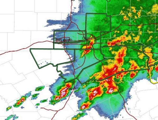
A significant outbreak of strong to severe thunderstorms is currently impacting North and Central Texas, according to the National Weather Service in Fort Worth. The agency issued an urgent update at 1:43 PM CDT, highlighting the ongoing threats of damaging winds, large hail, and the potential for tornadoes throughout the evening.
The most intense activity has been concentrated along and east of Interstate 35, with a particularly heightened tornado risk identified for areas from Hill and Ellis counties eastward through Freestone and Anderson counties later this afternoon. Forecasters warn that some of these tornadoes could be strong, fueled by robust updrafts and favorable atmospheric conditions. Residents in these areas are urged to remain vigilant and have a plan of action in case a tornado warning is issued.
Even outside the higher tornado risk zone, the entire Tornado Watch area, encompassing much of Central Texas, remains under threat as the storm system progresses eastward into the evening hours. Discrete storm cells, rather than the more linear convection, pose the most significant risk for intense severe weather.
READ: Deadly Derecho Leaves Millions Without Power Across Ohio Valley; 1 Dead In Pennsylvania
In addition to the severe weather threat, flash flooding is already occurring across the region and is expected to worsen. Many areas are likely to receive an additional 1 to 4 inches of rainfall, with isolated totals potentially reaching a dangerous 5 to 6 inches. The slow movement and backbuilding of storm cells, particularly south and east of the initial complex, have exacerbated the flooding concerns. Flash Flood Warnings are currently in effect for a large portion of the area, and the public is strongly advised to exercise extreme caution, especially when traveling. Motorists should avoid driving through flooded roadways.
While the current severe weather threat is expected to diminish late this evening, residents will only have a brief respite. The forecast indicates another complex of thunderstorms will move through North and Central Texas from Thursday night into Friday. This next wave of storms also carries a risk of large hail and damaging winds, especially if it becomes well-organized. Given the already saturated ground from today’s rainfall, the potential for additional flooding remains a concern.
Looking ahead, the weather is expected to improve just in time for the weekend. Saturday through Monday should bring mostly sunny skies and pleasant temperatures, with lows in the 50s and 60s and highs mainly in the 70s. However, the reprieve will be temporary, as another chance for storms is anticipated early to mid next week as an upper-level low pressure system moves into the Plains.
The ongoing thunderstorms are also affecting air travel in the region. The Dallas-Fort Worth (DFW) area is experiencing thunderstorms with rain, expected to continue through approximately 8 PM CDT, with lingering showers possible until 9 PM CDT.
Winds have been variable due to the storm activity but are generally from the north and are expected to remain so through early Thursday morning. In Waco, thunderstorms are developing to the north and are expected to impact the area between 2 PM and 5 PM CDT.
Please make a small donation to the Tampa Free Press to help sustain independent journalism. Your contribution enables us to continue delivering high-quality, local, and national news coverage.
Connect with us: Follow the Tampa Free Press on Facebook and Twitter for breaking news and updates.
Sign up: Subscribe to our free newsletter for a curated selection of top stories delivered straight to your inbox.

