A highly unusual weather pattern for early May has established itself across the United States, leading to prolonged periods of distinct weather conditions depending on location. Forecasters warn that this stagnant setup, known as an “Omega block,” will disrupt the typical west-to-east flow of weather systems, bringing steady rain and flood concerns to some areas while others experience varying temperatures.
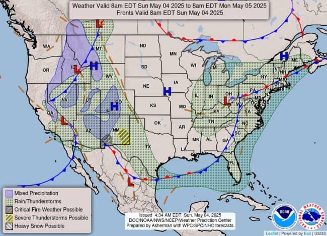
Named for its resemblance to the Greek letter Ω in upper-air atmospheric charts, the Omega block effectively traps weather systems in place. This creates two primary regions facing significant precipitation throughout the workweek: one stretching from the Southwest across the southern Plains and Gulf Coast, and another impacting the Northeast and Mid-Atlantic.
“Plenty of moisture will be underneath those lows,” stated FOX Weather Meteorologist Jane Minar. “It’s a slow-moving pattern that will kind of keep us locked in place with rain.”
The most significant impacts are expected across the South. Computer forecast models indicate widespread rainfall totals of 3 to 6 inches are likely, with localized areas potentially receiving even higher amounts. This heavy rain is expected to be accompanied by strong thunderstorms, some of which could reach severe levels with potential for hail and damaging wind gusts.
Cities in the predicted bull’s-eye for the heaviest precipitation include New Orleans, Louisiana; Jackson, Mississippi; and Alexandria, Louisiana. The situation is particularly concerning for communities in the region, many of which have already experienced torrential rainfall in recent weeks, leading to saturated ground and elevated river levels.
Authorities warn that the combination of recent rains and the impending heavy precipitation will significantly increase the risk of flooding, especially in low-lying or poorly drained areas.
READ: High-Speed 100 MPH Chase In Tampa Ends In Fiery Crash On Gandy Bridge Early Sunday
According to NOAA’s Weather Prediction Center (WPC), the highest flash flood risk is anticipated from Tuesday evening through early Wednesday. During this critical period, over 35 million people across the southern U.S. will be under Level 2 to Level 3 flash flood threats on the WPC’s 4-point risk scale, indicating a moderate to significant risk.
Meanwhile, the Northeast stands to benefit from the incoming rain. Forecast models predict 1 to 3 inches of rain across the Interstate 95 corridor, with potential for locally higher amounts of up to 5 inches in parts of New York and Connecticut. This rainfall is expected to provide welcome relief to regions along the Eastern Seaboard that have been experiencing moderate to severe drought conditions. While this type of pattern is generally not known for extensive severe weather outbreaks, localized severe weather remains a possibility.
Areas outside the influence of the stalled low-pressure systems will experience drier conditions but notable temperature variations. The northern Plains are expected to see unseasonable warmth, with high temperatures climbing into the 70s and 80s. In contrast, parts of the Southwest, including cities like Las Vegas and Los Angeles, may struggle to reach their average highs for early May. “It’ll feel more like Christmas in Los Angeles and the Fourth of July in Fargo,” Minar noted, highlighting the stark temperature contrast.
Forecasters anticipate that the stagnant Omega block pattern will begin to shift towards the upcoming weekend as the jet stream reasserts a more typical flow, allowing a return to a more standard springtime weather pattern across a large section of the country. Until then, residents in the affected areas should prepare for the possibility of prolonged rain and flooding in the South, needed moisture in the Northeast, and notable temperature swings elsewhere.
Please make a small donation to the Tampa Free Press to help sustain independent journalism. Your contribution enables us to continue delivering high-quality, local, and national news coverage.
Connect with us: Follow the Tampa Free Press on Facebook and Twitter for breaking news and updates.
Sign up: Subscribe to our free newsletter for a curated selection of top stories delivered straight to your inbox.


