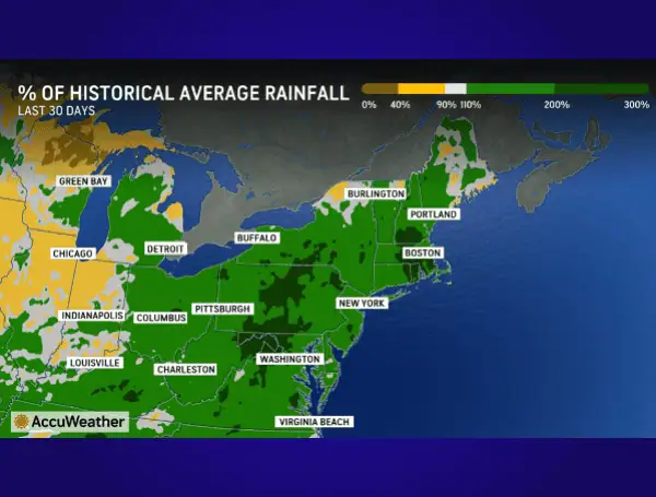
Weeks of persistent rain, thunderstorms, and drizzle have culminated in what AccuWeather meteorologists are calling one of the wettest Mays on record for at least 15 cities across the eastern and southern United States, with some records dating back over a century.
The deluge is far from over, with a high risk for severe thunderstorms forecast for parts of the Carolinas and Virginia today, and additional rain expected for the mid-Atlantic and Northeast through Saturday night.
The relentless precipitation throughout May has significantly impacted various sectors.
READ: NOAA And CSU Forecast Above-Normal 2025 Atlantic Hurricane Season, Urge Preparedness
“The frequency and amount of rain is having a negative effect on industries such as agriculture and construction,” stated AccuWeather Lead Long-Range Expert Paul Pastelok. “For example, farmers cannot cut and store wet hay, and workers cannot replace roofs during rainy weather.”
Beyond these industries, the soggy conditions have disrupted farming, tourism, outdoor activities, and events. Issues such as mildew and fungus are also becoming a concern, AccuWeather experts noted.
Remarkably, some areas have seen rainfall totals far exceeding their historical averages. Montgomery, Alabama, for instance, has recorded over 8.62 inches of rain this month, a staggering 222% of its typical May rainfall of 3.88 inches. Similarly, after a dry April, Allentown and Harrisburg, Pennsylvania, have experienced rainfall totals surging more than 200% above their historical May averages. Baltimore, Maryland, along with Roanoke and Charlottesville, Virginia, have also reported rainfall exceeding 130% of their norms.
“The wet conditions of May are making up for areas of dryness and drought in the Northeast during March and April,” said AccuWeather Senior Meteorologist and Climate Expert Brett Anderson. “Some places have received double or more than their historical average for May in New England, as well as portions of the South.”
READ: Powering Through Peril In Florida: Essential Generator Safety As Hurricane Season Looms
Severe Weather Threat Looms Friday
Compounding the existing saturation, AccuWeather meteorologists have issued a high risk of severe thunderstorms for Friday through Friday night across parts of South Carolina, North Carolina, and Virginia. “An unusually potent storm for this time of year coupled with copious amounts of moisture and instability has led to an upgrade in the risk level,” explained AccuWeather Senior Meteorologist Dan Pydynowski.
The primary concern is a potent line of thunderstorms developing Friday afternoon over the western Carolinas, which is expected to rapidly intensify as it moves eastward, reaching peak intensity along the I-95 corridor from southeastern Virginia through the Carolinas.
Cities within this heightened risk area include Richmond and Petersburg, Virginia; the Triangle area and Fayetteville, North Carolina; and Florence, South Carolina. Residents in these regions should prepare for possible hail, isolated tornadoes, and localized damaging wind gusts of 60-70 mph, with an AccuWeather Local StormMax of 80 mph.
READ: BBB Sounds Alarm: Floridians Urged To Prepare For “Above Average” 2025 Hurricane Season
“Widespread damaging wind gusts could cause power outages and tree damage,” Pydynowski warned, adding that the Friday evening commute could be significantly impacted by downpours.
Rain and storms on Friday are also possible as far south as eastern Louisiana and northern Florida, extending north to Washington, D.C., and parts of Maryland and Delaware.
Weekend Outlook: More Rain and a Chilly Start to June
The unsettled weather pattern will continue into Saturday. Gusty thunderstorms are anticipated from North Carolina up the East Coast to southeastern Pennsylvania and southern New Jersey, likely affecting Washington, D.C., Baltimore, Philadelphia, and potentially New York City. These storms could trigger localized urban flooding, small hail, sporadic tree damage, and power outages, with flight delays possible at major airports. Meanwhile, much of New England is bracing for more steady, drenching rain.
Rounds of heavy rain through Saturday morning could also lead to flash flooding in areas with already saturated soil across parts of West Virginia, Virginia, Maryland, Delaware, Pennsylvania, New Jersey, and New York.
A reprieve is expected for some by the end of the weekend, as a push of drier air is forecast to move into the South Central states and reach much of the Southeast by Sunday.
However, the start of June will bring a different kind of weather alert for millions in the Northeast and Great Lakes: a notable chill. AccuWeather RealFeel temperatures are forecast to plunge into the 30s across parts of Michigan, Pennsylvania, New York, and Vermont on Sunday morning.
Looking further ahead, while temperatures are expected to trend upward across the mid-Atlantic, Northeast, and Great Lakes by the middle of next week, the pattern of recurring showers and thunderstorms is likely to persist, with rain-free periods not expected to last more than two or three consecutive days. AccuWeather long-range experts also predict the return of severe weather next week, initially over portions of the southern Plains, eventually bringing more rain to the East Coast.
Please make a small donation to the Tampa Free Press to help sustain independent journalism. Your contribution enables us to continue delivering high-quality, local, and national news coverage.
Connect with us: Follow the Tampa Free Press on Facebook and Twitter for breaking news and updates.
Sign up: Subscribe to our free newsletter for a curated selection of top stories delivered straight to your inbox.

