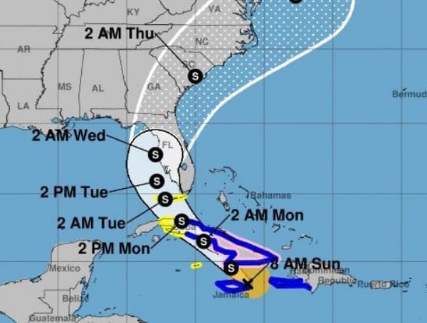
Please click here for the most updated track. At 5: 00 PM Tropical Storm Elsa is moving toward the northwest near 14 mph (22 km/h), and this general motion is expected to continue through Monday followed by a turn toward the north-northwest on Tuesday.
On the forecast track, Elsa will continue to move near or over eastern Cuba this evening, and approach central Cuba tonight and early Monday.
Elsa is expected to move across central and western Cuba and head toward the Florida Straits on Monday and pass near the Florida Keys early Tuesday. Elsa is then forecast to move near or over portions of the west coast of Florida on Tuesday and Wednesday.
Maximum sustained winds are near 60 mph (95 km/h) with higher gusts. Some strengthening is expected before Elsa moves over Cuba, followed by some weakening while the center moves over land. Slight restrengthening is possible after Elsa moves over the southeastern Gulf of Mexico.
Tropical-storm-force winds extend outward up to 90 miles (150 km) from the center.
SUMMARY OF WATCHES AND WARNINGS IN EFFECT:
A Tropical Storm Warning is in effect for…
- The Cuban provinces of Camaguey, Granma, Guantanamo, Holguin, Las Tunas, Santiago de Cuba, Ciego de Avila, Sancti Spiritus, Villa Clara, Cienfuegos, Matanzas, Mayabeque, and Havana
- Jamaica
- The Florida Keys from Craig Key westward to the Dry Tortugas
A Hurricane Watch is in effect for…
- The Cuban provinces of Camaguey, Granma, Guantanamo, Holguin, Las Tunas, and Santiago de Cuba
A Storm Surge Watch is in effect for…
- West coast of Florida from Bonita Beach to the Suwannee River
A Tropical Storm Watch is in effect for…
- Cayman Brac and Little Cayman
- The Cuban province of Artemisa
- The Florida Keys from east of Craig Key to Ocean Reef
- Florida Bay
- West coast of Florida from Flamingo northward to the Anclote River
Android Users, Click Here To Download The Free Press App And Never Miss A Story. It’s Free And Coming To Apple Users Soon.
Support journalism by clicking here to our gofundme or sign up for our free newsletter by clicking here


