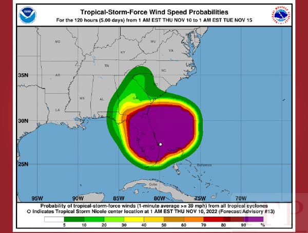
Nicole made landfall in Florida as a Category 1 hurricane early Thursday morning and quickly weakened to a tropical storm.
According to the National Hurricane Center (NHC), the storm weakened to a tropical storm after its landfall just south of Vero Beach.
At the 4 a.m. update, Nicole had maximum sustained winds of 70 mph and was moving west-northwest at 14 mph.
The worst of the weather is working its way through the region Thursday morning.
“On the forecast track, the center of Nicole will move across central Florida this morning, possibly emerge over the far northeastern Gulf of Mexico this afternoon, and then moving across the Florida Panhandle and Georgia tonight and on Friday,” the NHC said in the latest update. “Additional weakening is forecast while Nicole moves over land during the next day or two, and the storm is likely to become a tropical depression over Georgia tonight or early Friday.”
Storm surge estimates
* Jupiter Inlet Florida to Altamaha Sound Georgia, including the St. Johns River to the Fuller Warren Bridge: 3 to 5 ft
* Anclote River to Ochlockonee River: 3 to 5 ft
* Altamaha Sound Georgia to the South Santee River South Carolina: 2 to 4 ft
* St. Johns River south of the Fuller Warren Bridge to Georgetown Florida: 2 to 4 ft
* Ochlockonee River to Indian Pass: 2 to 4 ft
* Englewood to Anclote River including Tampa Bay: 1 to 3 ft
* Jupiter Inlet to Hallandale Beach Florida: 1 to 3 ft
* South Santee River to Surf City North Carolina: 1 to 2 ft
Rainfall estimates
* Northwest Bahamas into portions of the Florida Peninsula: 3 to 5 inches with local potential of up to 8 inches.
* Southeast into the central Appalachians and eastern portions of Tennessee, Kentucky, and Ohio: 2 to 4 inches with local potential of up to 6 inches along the Blue Ridge.
* Northern Mid-Atlantic into New England: 1 to 4 inches.
SUMMARY OF WATCHES AND WARNINGS IN EFFECT:
A Tropical Storm Warning is in effect for…
* Boca Raton Florida to South Santee River South Carolina
* North of Bonita Beach to Indian Pass Florida
* Lake Okeechobee
A Storm Surge Warning is in effect for…
* Jupiter Inlet Florida to Altamaha Sound Georgia
* Mouth of the St. Johns River to Georgetown Florida
* Anclote River Florida to Ochlockonee River Florida
A Storm Surge Watch is in effect for…
* Ochlockonee River to Indian Pass Florida
* Altamaha Sound Georgia to South Santee River South Carolina
Visit Tampafp.com for Politics, Sports, and National Headlines. Support journalism by clicking here to our GiveSendGo or sign up for our free newsletter by clicking here.
Android Users, Click Here To Download The Free Press App And Never Miss A Story. Follow Us On Facebook Here Or Twitter Here.

