
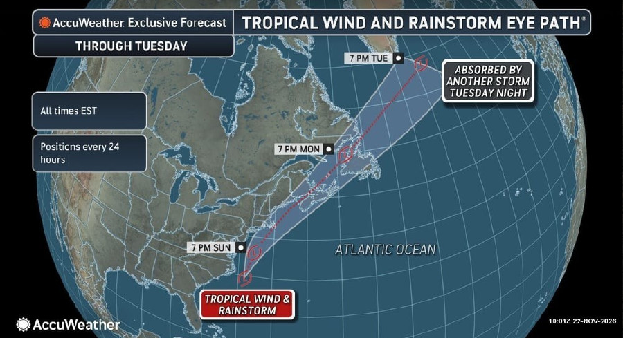
Early Thanksgiving week travelers along the East Coast face soaked highways, gusty winds, and coastal flooding as a slow-moving tropical storm creeps north on Sunday.
Before moving up the coast, the system unloaded massive amounts of rain on Florida, pushing November totals to double the historical average across much of the state—and up to eight times the norm in a few hard-hit spots. Madison recorded 12.07 inches of rain, while Aucilla saw 10.02 inches.
Though the worst downpours have moved out of Florida, much of the St. Johns River is already dealing with moderate to major flooding that could linger for weeks. That widespread flooding prompted AccuWeather to rate the storm a 1 on its RealImpact Scale for Hurricanes in the United States.
On Sunday, the storm is dumping another 1 to 2 inches of rain across far northeastern South Carolina and eastern North Carolina, with 2 to 4 inches expected in far southeastern North Carolina.
AccuWeather meteorologists say the storm will slowly intensify as it tracks toward coastal New England and Atlantic Canada, bringing rough weather through Monday night. Coastal areas stretching from far eastern Virginia to Atlantic Canada are in line for 1 to 2 inches of rain, while 2 to 4 inches could soak the stretch from the eastern tip of Long Island into parts of Atlantic Canada.

A heavier band of rain may drive totals even higher in southern New England. Through Monday night, the storm packs a Local StormMax of 11 inches of rain and 90 mph wind gusts.
The storm is also teaming up with a nearly full moon to create trouble along the shoreline. Because lunar pull already has tides running higher than usual, strong onshore winds and rough surf could chew away beaches and swamp low-lying streets across coastal New England and Atlantic Canada. Flood-damaged roads may take extra time to reopen.
“For communities along coastal New England and Atlantic Canada, the roughest hours may come around high tide. Tides are already running higher with the moon nearly full, and strong winds pushing water ashore can flood waterfront roads even during a break in the rain,” said AccuWeather meteorologist Haley Taylor.
Strong winds will add to the headaches through Monday night, with gusts of 40 to 60 mph possible across parts of southeastern Massachusetts and Atlantic Canada. Southern Nova Scotia faces the worst of the wind, where 60 to 80 mph gusts could snap trees and knock out power locally. Because of the combined threat of heavy rain, gusty winds and coastal flooding, the storm sits at less than a 1 on the AccuWeather RealImpact Scale for Hurricanes in Atlantic Canada.
Add The Tampa Free Press As A Preferred Source On Google
Please make a small donation to the Tampa Free Press to help sustain independent journalism. Your contribution enables us to continue delivering high-quality, local, and national news coverage.
